

Mae Hong Son, Thailand's northern border city, hiding itself in between the towering mountains with densely forested slopes, stretching to the Burmese border. Maehongson is known for its charm of scenery and culture. The people of Mae Hong Son consists of the Shans who live in the city and the hilltribe people who live in remote villages on mountain tops where elements of lifestyle have changed little in hundreds of years.
The Shans' ancestors came from Shans region in Burma. The hilltribe people consist of Karen, Lisu, Mhong, Lahu, and Lua. Both the Shans and the hilltribemen have their own distinctive cultures. They have their own lilting dialect, their own architectural lifestyles, their own customs and traditions, and their own delicious cuisine. Throughout the year, Maehongson holds many festivals and events. Tourists can observe the distinction cultures from these events. There are different dances, rituals, and ceremonies for different events and festivals. Even the foods are different for each event.
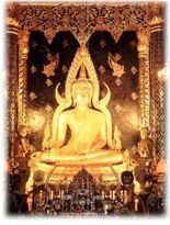
The most remarkable tradition and also the most important event for the Shans is "Poy Sanglong Festival" which is the ordination ceremony for the Shans' boys. The event is held in March and there is one big celebration throughout the city.
The city is covered with the mist all year long. Maehongson gains its nickna me of "the City of Three Mists" from the fact that it has dewy mist in the winter, forest fire mist in the summer and rainy mist in the rainy season.
The Shans' ancestors came from Shans region in Burma. The hilltribe people consist of Karen, Lisu, Mhong, Lahu, and Lua. Both the Shans and the hilltribemen have their own distinctive cultures. They have their own lilting dialect, their own architectural lifestyles, their own customs and traditions, and their own delicious cuisine. Throughout the year, Maehongson holds many festivals and events. Tourists can observe the distinction cultures from these events. There are different dances, rituals, and ceremonies for different events and festivals. Even the foods are different for each event.
The most remarkable tradition and also the most important event for the Shans is "Poy Sanglong Festival" which is the ordination ceremony for the Shans' boys. The event is held in March and there is one big celebration throughout the city.
The city is covered with the mist all year long. Maehongson gains its nickna
 me of "the City of Three Mists" from the fact that it has dewy mist in the winter, forest fire mist in the summer and rainy mist in the rainy season.
 Location and boundaries
Mae Hong Son Province is situated in northern and northwestern Thailand at 17° 38′ - 19° 48′ N and 97° 20′ - 98° 39′ E and furthest from Bangkok in the north at a distance of approximately 924 km. It boasts an area of approximately 12,681.259 km² or around 7,925,812.5 rai, which is third largest in Northern Thailand and seventh largest in the country. It is approximately 250 km from north to south and approximately 95 km from east to west.
To the north and west it connects to a total of three states in the Union of Burma, namely the southern portion of Shan State; Kayah State and Kawthoolei State via the West Thanon Thongchai Mountains and the rivers Salween and Moei which serve as natural boundaries between the countries. To the south it connects to the district of Tha Song Yang, Tak via the rivers Yuam and Ngao which serve as a provincial boundary. To the east it connects to the districts of Wiang Haeng, Chiang Dao, Mae Taeng, Mae Chaem, Hot and Omkoi in Chieng Mai Province via the Central and East Thanon Thongchai mountain ranges that serve as a boundary line between the two provinces.
Every district in Mae Hong Son Province shares a common border with the Union of Burma approximately 483 kilometres in total length. Of this, approximately 326 kilometres is land and 157 kilometres are rivers (not counting the Salween, 127 km, and Moei, 30 km).
Geography
Most of the areas of Mae Hong Son Province are complex mountain ranges and likely still pristine virgin forest. Of the approximately 6,976,650 rai of national forest reserves, 88.02% is thought to be pristine virgin forest. Mountain ranges run unbroken from north to south with important mountain ranges being the Lao-territory mountains located on the northernmost portion of the province that serve as a boundary between Thailand and the Union of Burma and the Thanon Thongchai Mountains which are in fact three adjoining ranges, the East, West and Central Thanon Thongchai mountain ranges respectively; the West Thanon Thongchai Mountains serve as a boundary between Thailand and the Union of Burma. The mountains in the east of the province serves as the boundary between the provinces of Mae Hong Son and Chiang Mai. The tallest point is Mae Ya Peak of the East Thanon Thongchai Mountains in the Pai District in the province's northeast, at 2005 metres above sea level.


No comments:
Post a Comment