สายลมที่หวังดี - สุเมธ

Geography

Phitsanulok province covers some 10,584.5 sq. km. The riverside provincial capital is 377 km. North of Bangkok. Phitsanulok is situated on the geographical and administrative line uniting the central and northern regions. Phitsanuloke, located in Central Northern Thailand is a modern city. Ideal as a stepping stone for the Northern visitors attractions including Sukothai.
Phitsanulok was the birthplace of King Naresuan the Great of Ayuthaya (reign : 1590 - 1605), and his brother Prince Ekathosarot. Phitsanulok has long been an important center for political and strategic reasons. Phitsanulok was a major center of recruitment when Ayuthaya waged war with Burma, and was the capital of Thailand for 25 years during the 1448-1488 reign of Ayuthaya’s King Boromtrailokanat.
The climate of Phitsanulok is generally hot and humid. It borders with Uttaradit in he North, Pichit in the south, Loei and Phetchabun in the East, Kamphaeng Phet and Sukhothai in the West. Covering an area of 10,815.8 sq.km., the province is divided into 9 Amphoes : Muang , Bang Rakam , Nakhon Thai , Phrom Priram , Wat Bot - BangKrathum , Chat Trakan , Noen MaPrang , Wang Thong

City Attraction

Wat Phra Si Rattana Mahathat his monastery commonly called by the inhabitants as "Wat Yai" is the most important monastery of Phitsanulok, the home of the famous Phra Buddha Chinnarat. It is located at the foot of Naresuan Bridge on the city side of the river.The monastery was built in the reign of Phra Maha Thamma Racha I (Phraya Lithai) In 1357 A.D. It houses the Phra Buddha Chinnarat regarded as the most beautiful Buddha image in Thailand. It is cast in the attitude of subduing evil. Later, in 1631, King Ekatosarot graciously bestowed some of his gold regalia to be beaten into gold - plate and applied them to the image worth his own hands, creating its most beautiful Buddha image. There are many other beautiful and noteworthy items in the monastery compound. The mother - of - pearl inlaid wooden doors of Vihara are especially splendid, and were built by King Boromkot in 1756 as a dedication to phra Buddha Chinarat. Behind the Vihara, there is a large Prang 36 meters high, with a staircase leading up to the niche containing the Buddha relics. In front of the Prang, there is Phra Attharos, and on the 9 room Vihara slope. There remains only the newly-renovated Buddha image.
Wat Ratchaburana nad Wat Nang Phya Is located on the eastern bank of the Nan river, near Wat Phra Si Rattana Mahathat to the south. These two monasteries, assumed to be built when Phitsanulok City was ruled by King Boromtrailokanat, have linking compounds. Wat Nang Phya has temple or bot but it is known for the so-called "Phra Nang Phya" votive tablets special fine form of the 3-head nagas decorated on their eaves.
King Naresuan the Great Shrine The shrine is located in the compound of the Phitsanulok Phittayakom school, and depicts the seated king ceremoniously declaring Ayuthaya's independence from Burma. The shrine was constructed on the site of the Channdra Palace where King Naresuan was born in 1555.

Sunday, April 27, 2008

Chiang Saen National Museum


The ancient city of Chiang Saen which is one of the most important cities of the Lan Na Kingdom and admits a large number of archaeological sites, both prehistoric and historic periods was established by command of King Saen Pu in 1328.
Archaeological and historical evidences manifested that Chiang Saen has a long development of complex cultures. The location on the west bank of the Mekong River is appropriate for human settlement that could develop itself into a center for tread as well as into a town of economic and political importance. The architectural remains are sources of strength to the written records that the city was fully advanced in the 14th century.

The Chiang Saen National Museum, Which is a site museum under the Department of Fine Arts, was established in the old sala (Buddhist building) of Wat Chedi Luang in 1957 as the center for collecting and displaying archaeological artifacts found from excavation and restoration of the ruins in the ancient city of Chiang Saen and its vicinity. It is situated in the ancient city of Chiang Saen, in 1981 it was allocated a budget to complete the new building as planned. The main exhibition hall is constructed in the applied - Lan Na architectural style.

The main purpose of the collection is to emphasize history, art and archaeology related to human settlement, and artifacts from prehistoric to historic periods for the purpose of study and pleasure.

H.R.H. Princess Maha Chakri Sirindhorn graciously opend the museum on March 7, 1997.

The Chiang Saen National Museum occupies the entire space of a rectangular shaped one storey building and the addition past of U-shaped wing, so the museum exhibition can be divided into 3 sections as follows :

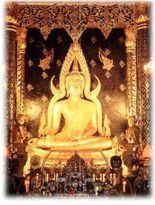
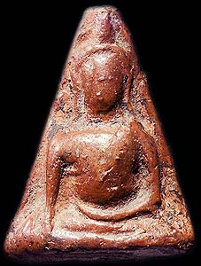
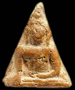
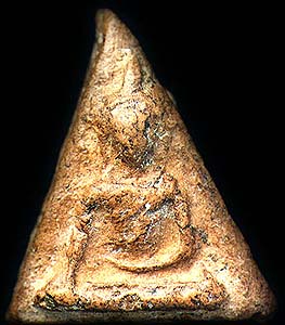
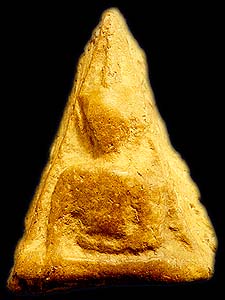
First Section The storey - inside a major exhibition hall on the lower floor displays : the location of the settlement at Chiang Saen, Inscriptions was found from Chiang Saen and its vicinity and stucco decoration from Wat Pa Sak including the world reknowned sculpture of the kirtimuka (kala face). Another attractive point of the main exhibition hall is the flame final of the Heavenly Golden Budha and the Lan Na Buddha images in Chiang Saen style, the excavations and restorations of the ruins in Chiang Saen and its vicinity.

Second Section The storey - inside a major exhibition hall on the upper floor displayed important sculptures in Chiang Saen and artifacts from excavation and renovation of ancient monuments in Chiang Saen and also it's surrounding area.

Third Section The exhibitions are Northern Thai ceramics in Chiang Rai province and the other related wares, the Mekong River, religious objects, and folk art of the northern minority groups in Ching Rai Province such as the Thai Yuan, Thai Yai, Thai Lue, and various hill tribes in Chiang Saen District including Mien (Yao), Akha (Ekaw), and Hmong (Maew). Also Shown are tools and basketry of various ethnic groups.

Nan National Museum


The Nan National Museum, is located at the original site of the palace of the Feudal Lord of Nan. The building was originally constructed by Phrachao Suriyaphong Pharitdeg, the Lord of Nan, in 1903 to replace for his former wooden residene. Afer the dearh of Chao Maha Brahma Surathada, the last Frudal Lord of Nan, his descendants donated this palace to the government in 1931 for use as the to provincial hall. In 1973 the Fine Arts Department was permitted to use this building and location for establishing the National Museum after the new provincial hall building had been provided by the Ministry of Interior.
The National Museum of Nan is simultaneously an art history, archaeological and ethnological museum. The exhibitions are arranged to emphasize mainly these aspects. They are separated into two parts. The exhibition rooms on the second floor of thee building feature art history and archaeological data and evidence, The rooms on the ground floor exhibit ethnological data concerning the native people and the minority groups living within the boundaries of Nan Province.

The exhibition rooms on the second floor are divided into two sections. The first is the main hall which used to be the throne hall of family tree of the Feudal Lord, historical photo graphs, art objects, ancient currency, weapons and inscriptions. The second consists of the rooms in the north and south wings including the verandah in the back of the building, forming a total of 6 exhibition rooms. They are used for exhibition art history and archaeological ingormation and fondings remaining from Prehistoric times until the Historical Period, i.e. early settlements in Nan province; the influences of the Lan Na and Sukhothai Art Styles in the development of the Nan Art Styles, etc. The last room exhibit black elephant tusks which have been considered the invaluable treasure of Nan Town since ancient times.

The 6 exhibition rooms on the ground floor are also divided into two sections. The first is the main hall and 2 other rooms in the north wing. They are used for exhibiting the ethnological data concerning the native's way of life, i.e. house design, utensils used in everyday life, cloth weaving and various styles of local cloth products, some local customs, rituals and beliefts, etc. The second is composed of a hall and 2 other rooms in the south wing. They are used for exhibiting the way of life of 5 minority groups : the Tai Lue, the Hmong, the Yao, the Thin and the Mlabri (Tong Luang). Some realistic models and scenes are also on exhibit.

Pha Chu, or Pha Cherdchu


Pha Chu, or Pha Cherdchu is a cliff located within the Si Nan National Park which covers extensive forested and mountainous areas. To reach the cliff can be reached by taking the Nan-Wiang Sa-Na Noi route for 135 kms then turning into Highway #1083 and on for another 22 km. The cliff-stop offers an excellent viewing point to enjoy a panoramic vista of the mountains. A national flag pole has a lanyard running all the way down to the foot of the hill, the longest in the country. There are camping areas for visitors in the parks.

How To Get There (Nan province)

By Car

From Bangkok, take Highway No.32 to Nakhon Sawan and use Highway No.117 to Phitsanulok, Highway No.11 to Amphoe Den Chai, then take Highway No.101 to Nan via Phrae, a total distance of 668 kilometres.

By Bus

Transport Co. Ltd. operates bus services from Bangkok's Mochit 2 Bus Terminal to Nan every day. Call 0 2936 2852-66 for more information. Other private companies are such as Phrae Tour Tel: 0 2245 2369, Sombat Tour Tel: 0 2936 2495-6 and Choetchai Tour Tel: 0 5471 0362 (Nan Office).

By Air

Thai Airways International flies from Bangkok to Nan every day. Call 1566

Nan Traditional Boat Race


The Traditional Boat Race is held in October or November each year when the Nan River flows swiftly past the province. It is incorporated with the celebrations of the Black Ivory and the local Kathin ceremony. Boats are dugouts made from large logs ad beautifully decorated. Manned by well-trained oarsmen, the racing boats are lustily cheered on by spectators lining both banks of the river.

Golden Orange and Red Cross Fair in Nan province


The fair is held annually around mid-December at the Provincial Stadium. The golden orange, with golden peel and a sweet taste, is a famous crop of Nan Province. The orange's gold color results from the difference between day time and night time temperature. Main features in the fair include beauty contests, Golden orange parade contest, Contest, booths displayed by the government and private sectors, and various entertainment.

Thursday, April 17, 2008

Amulet of Nan


Seal of nan Province


The provincial seal shows a Usuparatch bull carrying the pagoda of Phrathat Chae Haeng. The buffalo goes back to a legend that the rules of Nan and Phrae were brothers, and met at a mountain to decide about the boundary between their lands. The ruler of Nan went there on a buffalo, while the ruler of Phrae went there on a horse.
The provincial tree and provincial flower is the Orchid Tree (Bauhinia variegata).

History of Mae Hong Son


It is believed that the lands of Mae Hong Son had already been settled before the arrival of Lord Kaeo of Ma (Chao Kaeo Mueang Ma) and his consequent resettlement in the area. However, there is no evidence as to what time or period they arrived, nor of their migrations thereafter. These former inhabitants have left evidence of their activity in the area and are believed to have been Lua, or Lawa, tribespeoples. Evidence to date includes gravesites and discarded housing structures such as those found in the vicinity of the Mae Hong Son Municipal Hall, nowadays the Morning Markets and Dharma School, by the Chong Klang and Chong Kham monasterial compound. These first settlers were likely depopulated by either malaria or war, with survivors then dispersing out to safer areas.

The old, pre-Rattanakosin lands of Mae Hong Son was merely a collective of forest settlements without a central government, with Shan peoples who had crossed into the area from beyond the frontier with the Union of Burma in search of a means to find food, working in agroforestry and joint plantations as the seasons permitted. During this period the area was significant only as a passage for Burman troops marching on the capital at Ayutthaya or to the various Siamese capitals of Northern Thailand.

Mae Hong Son historical records state that in the year 1831, which corresponds to the reign of King Nangklao (Rama III) of the Rattanakosin Period, in the mueang of Phing Nakhon known today as Chiang Mai, in the lands of the Kingdom of Lannathai, was Phraya Chiang Mai Mahawong, who was later to ascend to the rank of Phra Chao Mahottraprathet Racha Thibodi, who knew that to the west of Chiang Mai, which meant the lands of today’s Mae Hong Son, was a geography of tall mountains and dense forests inhabited by a myriad of forest creatures of which wild elephants in particular were in great abundance, and thus ordered Lord Kaeo, who was a relative of his and a local military chief and governor, to herd these elephants out into the custody of mahouts, to survey the feasibility of this task on such western frontierlands and to be of further service in the capturing of the elephants so that they might be trained for labour thereafter.

Lord Kaeo assembled his troops, lure-elephants and mahouts and set out from Chiang Mai, bound for a shortcut which entered northeast along a brook leading them to complex mountain ranges. After a short trip they arrived in the hamlet of Wiang Pai, or Amphoe Pai as it is known today. Here, Kaeo and his commission stopped a while before resuming their expedition. They then headed south to find a shortcut along the Pai River, so that they might ascend into the mountains once more.

After travelling for a longer period this time, they then headed back towards the Pai River. On arrival, they found a tiny community living in the area, either Shan or otherwise Tai, with hamlets along the Pai River amid vast areas of thick, virgin forest. Lord Kaeo deemed this location most suitable to build a village, with ample land to extend the scope of the village in the future and abundant saltlicks nearby the houses for boars; all one required in maintaining a successful village.

Lord Kaeo then rehabilitated the various scattered settlements into a single village and had them elect a leader referred to as a Heng; Phakamong, a Shan, was thus elected as the village heng. (The village elder, or kamnan, ruled over the village, and it was then named Ban Pong Mu, or Village of the Boar Saltlick. It later became Ban Pang Mu, Tambon Pang Mu, Amphoe Pang Mu, Changwat Mae Hong Son. Lord Kaeo, together with Phakamong, then travelled further south with a number of their elephants in tow into the realm of what is today’s Mae Hong Son. Finding it a suitable location with a stream flowing by from east to west into the Pai River and a second brook running further north, he decided it would be most fitting to establish his elephant training camp there along with a residential base for personnel. Subsequently, he constructed an elephant pen on the banks of the stream and the area became another village for the Shan settlers, although with a smaller population than that of Ban Pong Mu. After Lord Kaeo had captured the satisfactory quota of elephants and had trained them as instructed, he decided to head back, and so elected the son-in-law of Phakamong, Saenkom, as the Kang or village chief to oversee the village and it was then that the village was named Ban Mae Rong Son, or Village of the Elephant Training Camp Bayou; later, the name Mae Rong Son was corrupted to Mae Hong Son, as pronounced in the brogue of the Lannanese (initial r’s are often pronounced as h’s), and the aforementioned second brook that ran north was named Lamnam Pu on finding water there splashing up from the earth (lamnam refers to any body of flowing water; pu is the sound produced when throwing a stone or brick into the mud or against a soft substance).

The village of Mae Rong Son flourished and prospered and Shan began migrating there in increased numbers. Aside from this wave, in around the year 1856 there arose much political unrest on the western banks of the Salween River which furthered the influx of peace-loving Shan, and again in 1876 when war broke out between the blood-princes of the principalities of Nai and Mok Mai respectively. Prince Kolan of Mok Mai, unable to sustain the battle, moved his family to live with Saenkom in Mae Rong Son along with his wife Nang Khiao, their son Khun Long, their grandson Khun Ae and their granddaughters, Chao Nang Nu and Chao Nang Mia.

By 1874, with the village of Mae Rong Son having become a huge community with a constant influx of migrants and so it was agreed that it should change its status to that of a fully fledged mueang. Lord Inthawichayanon, Lord of Chiengmai, thus elected a Shan named Chankale to be its first partasakti (somewhere between a count, in non-prerogative terms, and a governor) and bestowed on him the title of Phaya Singhanat Racha, or Sacred Voice of the King of the Singh, who would govern the mueang of Mae Hong Son from 1874, corresponding to the Rattanakosin Period of Rama V.

Later, in 1884, after caring for the mueang of Mae Hong Son for a decade, Phaya Singhanat Racha died. The next ruler was Chao Nang Mia, who ruled for seven years, bringing the realm to further great prosperity before passing away in 1891.

The next Lord of Mae Hong Son was Tho, referred to as Pu Khun Tho or Old Man Tho the Mandarin, who was made partasakti with the title Phaya Phithak Sayam Khet, or Lord Protector of the Fertile Soils of Siam. He governed the mueang of Mae Hong Son between 1891 to 1905 before his own passing that year.

The next figure to rule as Lord of Mae Hong Son was Khun Lu, the son of Pu Khun Tho, who reigned in his place as partasakti with the title Phaya Phisan Hong Son Buri, or Lord of the Metropolis of Hong Son Most Vast. He governed over Mae Hong Son between the years 1905 to 1941. To follow was a period of change in government administration and there would be no more such ranks and titles.

In 1890, during the reign of Rama V of Bangkok, Phraya Si Sahathep, Plat Thun Chalong of the Ministry of the Interior, completed an inspection tour of the cities in the Northwestern Mandala (see also Mandala (Southeast Asian history) and Mandala for perspective) and consulted with High Commmisioner Phraya Ritsaratchakit, who oversaw the Northwestern Mandala, to organise a new order of governance, namely, he would incorporate the partially independent city-states of Mae Hong Son, Khun Yuam, Yuam (Mae Sariang) and Pai into a single unit of government to be called the Boriwen Chiang Mai Tawantok, or Shire of Western Chiang Mai, and placed the government of the shire (which was now comparable to that of a single mueang) at Khun Yuem by appointing Nai Mot as shire reeve (as stated by the Minister for the Interior on July 11, 1901).

In 1903, the seat of government was moved from Khun Yuam to Yuam and the administrative division was renamed from Western Chiang Mai to Northern Phayap. In 1910, a royal decree saw the merging of Mae Hong Son, Yuam and Pai into a fourfold realm alongside the Mandala of Phayap, and moved the administrative capital to Mae Hong Son with Phraya Sonsurarat (Plueng) as the first Governor of Mae Hong Son Province. In 1933, governance as a territory was ceased and then reinstated as a constitutional administrative government as per the Constitution of the Kingdom of Thailand as remains in place today.

Mae Hong Son Province


Mae Hong Son, Thailand's northern border city, hiding itself in between the towering mountains with densely forested slopes, stretching to the Burmese border. Maehongson is known for its charm of scenery and culture. The people of Mae Hong Son consists of the Shans who live in the city and the hilltribe people who live in remote villages on mountain tops where elements of lifestyle have changed little in hundreds of years.

The Shans' ancestors came from Shans region in Burma. The hilltribe people consist of Karen, Lisu, Mhong, Lahu, and Lua. Both the Shans and the hilltribemen have their own distinctive cultures. They have their own lilting dialect, their own architectural lifestyles, their own customs and traditions, and their own delicious cuisine. Throughout the year, Maehongson holds many festivals and events. Tourists can observe the distinction cultures from these events. There are different dances, rituals, and ceremonies for different events and festivals. Even the foods are different for each event.

The most remarkable tradition and also the most important event for the Shans is "Poy Sanglong Festival" which is the ordination ceremony for the Shans' boys. The event is held in March and there is one big celebration throughout the city.

The city is covered with the mist all year long. Maehongson gains its nickname of "the City of Three Mists" from the fact that it has dewy mist in the winter, forest fire mist in the summer and rainy mist in the rainy season.

Location and boundaries
Mae Hong Son Province is situated in northern and northwestern Thailand at 17° 38′ - 19° 48′ N and 97° 20′ - 98° 39′ E and furthest from Bangkok in the north at a distance of approximately 924 km. It boasts an area of approximately 12,681.259 km² or around 7,925,812.5 rai, which is third largest in Northern Thailand and seventh largest in the country. It is approximately 250 km from north to south and approximately 95 km from east to west.

To the north and west it connects to a total of three states in the Union of Burma, namely the southern portion of Shan State; Kayah State and Kawthoolei State via the West Thanon Thongchai Mountains and the rivers Salween and Moei which serve as natural boundaries between the countries. To the south it connects to the district of Tha Song Yang, Tak via the rivers Yuam and Ngao which serve as a provincial boundary. To the east it connects to the districts of Wiang Haeng, Chiang Dao, Mae Taeng, Mae Chaem, Hot and Omkoi in Chieng Mai Province via the Central and East Thanon Thongchai mountain ranges that serve as a boundary line between the two provinces.

Every district in Mae Hong Son Province shares a common border with the Union of Burma approximately 483 kilometres in total length. Of this, approximately 326 kilometres is land and 157 kilometres are rivers (not counting the Salween, 127 km, and Moei, 30 km).

Geography
Most of the areas of Mae Hong Son Province are complex mountain ranges and likely still pristine virgin forest. Of the approximately 6,976,650 rai of national forest reserves, 88.02% is thought to be pristine virgin forest. Mountain ranges run unbroken from north to south with important mountain ranges being the Lao-territory mountains located on the northernmost portion of the province that serve as a boundary between Thailand and the Union of Burma and the Thanon Thongchai Mountains which are in fact three adjoining ranges, the East, West and Central Thanon Thongchai mountain ranges respectively; the West Thanon Thongchai Mountains serve as a boundary between Thailand and the Union of Burma. The mountains in the east of the province serves as the boundary between the provinces of Mae Hong Son and Chiang Mai. The tallest point is Mae Ya Peak of the East Thanon Thongchai Mountains in the Pai District in the province's northeast, at 2005 metres above sea level.