สายลมที่หวังดี - สุเมธ

Geography

Phitsanulok province covers some 10,584.5 sq. km. The riverside provincial capital is 377 km. North of Bangkok. Phitsanulok is situated on the geographical and administrative line uniting the central and northern regions. Phitsanuloke, located in Central Northern Thailand is a modern city. Ideal as a stepping stone for the Northern visitors attractions including Sukothai.
Phitsanulok was the birthplace of King Naresuan the Great of Ayuthaya (reign : 1590 - 1605), and his brother Prince Ekathosarot. Phitsanulok has long been an important center for political and strategic reasons. Phitsanulok was a major center of recruitment when Ayuthaya waged war with Burma, and was the capital of Thailand for 25 years during the 1448-1488 reign of Ayuthaya’s King Boromtrailokanat.
The climate of Phitsanulok is generally hot and humid. It borders with Uttaradit in he North, Pichit in the south, Loei and Phetchabun in the East, Kamphaeng Phet and Sukhothai in the West. Covering an area of 10,815.8 sq.km., the province is divided into 9 Amphoes : Muang , Bang Rakam , Nakhon Thai , Phrom Priram , Wat Bot - BangKrathum , Chat Trakan , Noen MaPrang , Wang Thong

City Attraction

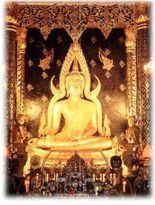
Wat Phra Si Rattana Mahathat his monastery commonly called by the inhabitants as "Wat Yai" is the most important monastery of Phitsanulok, the home of the famous Phra Buddha Chinnarat. It is located at the foot of Naresuan Bridge on the city side of the river.The monastery was built in the reign of Phra Maha Thamma Racha I (Phraya Lithai) In 1357 A.D. It houses the Phra Buddha Chinnarat regarded as the most beautiful Buddha image in Thailand. It is cast in the attitude of subduing evil. Later, in 1631, King Ekatosarot graciously bestowed some of his gold regalia to be beaten into gold - plate and applied them to the image worth his own hands, creating its most beautiful Buddha image. There are many other beautiful and noteworthy items in the monastery compound. The mother - of - pearl inlaid wooden doors of Vihara are especially splendid, and were built by King Boromkot in 1756 as a dedication to phra Buddha Chinarat. Behind the Vihara, there is a large Prang 36 meters high, with a staircase leading up to the niche containing the Buddha relics. In front of the Prang, there is Phra Attharos, and on the 9 room Vihara slope. There remains only the newly-renovated Buddha image.
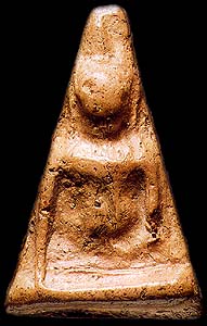
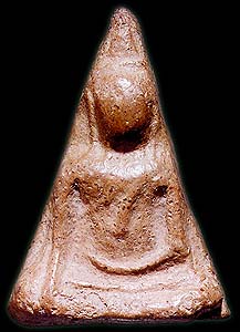
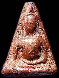
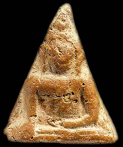
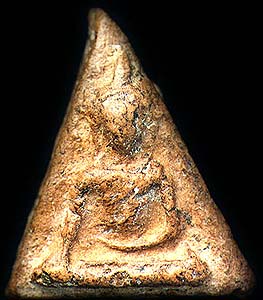
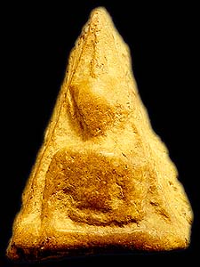
Wat Ratchaburana nad Wat Nang Phya Is located on the eastern bank of the Nan river, near Wat Phra Si Rattana Mahathat to the south. These two monasteries, assumed to be built when Phitsanulok City was ruled by King Boromtrailokanat, have linking compounds. Wat Nang Phya has temple or bot but it is known for the so-called "Phra Nang Phya" votive tablets special fine form of the 3-head nagas decorated on their eaves.
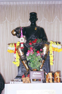
King Naresuan the Great Shrine The shrine is located in the compound of the Phitsanulok Phittayakom school, and depicts the seated king ceremoniously declaring Ayuthaya's independence from Burma. The shrine was constructed on the site of the Channdra Palace where King Naresuan was born in 1555.
Showing posts with label Nan. Show all posts

Sunday, April 27, 2008

Nan National Museum


The Nan National Museum, is located at the original site of the palace of the Feudal Lord of Nan. The building was originally constructed by Phrachao Suriyaphong Pharitdeg, the Lord of Nan, in 1903 to replace for his former wooden residene. Afer the dearh of Chao Maha Brahma Surathada, the last Frudal Lord of Nan, his descendants donated this palace to the government in 1931 for use as the to provincial hall. In 1973 the Fine Arts Department was permitted to use this building and location for establishing the National Museum after the new provincial hall building had been provided by the Ministry of Interior.
The National Museum of Nan is simultaneously an art history, archaeological and ethnological museum. The exhibitions are arranged to emphasize mainly these aspects. They are separated into two parts. The exhibition rooms on the second floor of thee building feature art history and archaeological data and evidence, The rooms on the ground floor exhibit ethnological data concerning the native people and the minority groups living within the boundaries of Nan Province.

The exhibition rooms on the second floor are divided into two sections. The first is the main hall which used to be the throne hall of family tree of the Feudal Lord, historical photo graphs, art objects, ancient currency, weapons and inscriptions. The second consists of the rooms in the north and south wings including the verandah in the back of the building, forming a total of 6 exhibition rooms. They are used for exhibition art history and archaeological ingormation and fondings remaining from Prehistoric times until the Historical Period, i.e. early settlements in Nan province; the influences of the Lan Na and Sukhothai Art Styles in the development of the Nan Art Styles, etc. The last room exhibit black elephant tusks which have been considered the invaluable treasure of Nan Town since ancient times.

The 6 exhibition rooms on the ground floor are also divided into two sections. The first is the main hall and 2 other rooms in the north wing. They are used for exhibiting the ethnological data concerning the native's way of life, i.e. house design, utensils used in everyday life, cloth weaving and various styles of local cloth products, some local customs, rituals and beliefts, etc. The second is composed of a hall and 2 other rooms in the south wing. They are used for exhibiting the way of life of 5 minority groups : the Tai Lue, the Hmong, the Yao, the Thin and the Mlabri (Tong Luang). Some realistic models and scenes are also on exhibit.

Pha Chu, or Pha Cherdchu


Pha Chu, or Pha Cherdchu is a cliff located within the Si Nan National Park which covers extensive forested and mountainous areas. To reach the cliff can be reached by taking the Nan-Wiang Sa-Na Noi route for 135 kms then turning into Highway #1083 and on for another 22 km. The cliff-stop offers an excellent viewing point to enjoy a panoramic vista of the mountains. A national flag pole has a lanyard running all the way down to the foot of the hill, the longest in the country. There are camping areas for visitors in the parks.

How To Get There (Nan province)

By Car

From Bangkok, take Highway No.32 to Nakhon Sawan and use Highway No.117 to Phitsanulok, Highway No.11 to Amphoe Den Chai, then take Highway No.101 to Nan via Phrae, a total distance of 668 kilometres.

By Bus

Transport Co. Ltd. operates bus services from Bangkok's Mochit 2 Bus Terminal to Nan every day. Call 0 2936 2852-66 for more information. Other private companies are such as Phrae Tour Tel: 0 2245 2369, Sombat Tour Tel: 0 2936 2495-6 and Choetchai Tour Tel: 0 5471 0362 (Nan Office).

By Air

Thai Airways International flies from Bangkok to Nan every day. Call 1566

Thursday, April 17, 2008

Seal of nan Province


The provincial seal shows a Usuparatch bull carrying the pagoda of Phrathat Chae Haeng. The buffalo goes back to a legend that the rules of Nan and Phrae were brothers, and met at a mountain to decide about the boundary between their lands. The ruler of Nan went there on a buffalo, while the ruler of Phrae went there on a horse.
The provincial tree and provincial flower is the Orchid Tree (Bauhinia variegata).

Monday, March 10, 2008

Doi Phu Kha National Park.


To the north of Nan along highway No. 1080 in Nong Bua district and with a further distance of 25 kilometers on the route to Bo Klua district lies the Doi Phu Kha National Park. The terrain is mainly forested lands on limestone mountain ranges, the source of several streams which merge into the Nan River. The elevation is about 1,900 metres above sea level. Here are found several rare and near-extinct flora, particularly the Chomphu Phu Kha [bretschneidera ninesis hemsl.], whose pink flowers are in full bloom during February. In the morning, a sea of mist can be seen drifting across the valley. There are also several scenic waterfalls and the Wa brook waiting for tourists who like to shoot the many rapids. Permits to camp can be applied for. Alternatively, tourists may choose to utilize the accommodation services in the park.

Climate
Three main seasons are characteristic in the park. There is they rainy season, May to October, with the peak rainfall in August and September. The cold season (November-February) is the most popular time to visit the park.


Contact : Phu Kha Sub-district, Amphur Pua Nan Thailand 55120Tel. 0 5470 1000, 0 5473 1362 Fax 0 5473 1362 E-mail phukha_np@hotmail.com

Nan Province


A quiet and tranquil province, Nan nestles in a valley in Northern Thailand. About 668 kilometres from Bangkok, it covers an area of 11,472 square kilometres and is made up of the following districts: Muang, Wiang Sa, Na Noi, Pua, Chiang Klang, Tha Wang Pha, Thung Chang, Mae Charim, Ban Luang, Na Mun, Santisuk, Bo Klua, Chaleom Phra Kiat, Song Kwae, and Phu Phiang.

The people of Nan descend from the Lan Changs (Laotians). Their forebears moved to settle around present day Pua district which is rich in rock salt deposits, about 700 years ago at the time when Sukhothai was becoming the kingdom of the Thais. They subsequently moved south to the fertile Nan River basin which is much more extensive. Nan's history is deeply involved with its neighbours, in particular Sukhothai which played an important role in both political and religious terms before Nan became a part of Lanna, Burma and Thailand in that order. Today Nan is still the home of numerous Thai Lu and other hill tribes who retain highly interesting customs and traditions.


For centuries Nan was an independent kingdom but, due to its remoteness, had few connections to the other kingdoms. The first kingdom around the city Mueang Pua (also known as Varanagara) was created in the late 13th century. Its rulers, the Phukha dynasty, were related to the founders of Vientiane, however it became associated with the Sukhothai kingdom as it was easier to reach from the south than from the east or west. In the 14th century the capital was moved to its present location at Nan.
In the 15th century, when Sukhothai declined in power, it became vassal of the kingdom of Lannathai. In 1443 King Kaen Thao of Nan plotted to capture neighboring Phayao by asking King Tilokaraj to help him fight against Vietnamese troops attacking Nan, even though there was no such threat. Kaen Thao killed the king of Phayao, however the troops of Tilokaraj then attacked Nan itself, and captured it in 1449.
When Lannathai was under Burmese rulership, Nan tried to liberate itself many times without success, which finally led to direct Burmese rulership of Nan in 1714. In 1788 the Burmese rulers were finally driven back, however Nan had to then accepted the new Siam rulers. In 1893 after the Paknam crisis Siam had to give a big part of eastern Nan to French Indochina.
However Nan kept some degree of independence from the Siamese rulers, and it took until 1931 to become fully integrated into Thailand, and the province was then created.
Before the early 1980s bandits as well as People's Liberation Army of Thailand (PLAT) guerillas were a big problem in the province, usually destroying highway construction overnight. With the help of the army and the more stable political system the province improved significantly, but is still a very rural and remote area.

Administrative divisions

The province is subdivided in 15 districts (Amphoe). These are further subdivided into 99 subdistricts (tambon) and 848 villages (muban).

  1. Mueang Nan
  2. Mae Charim
  3. Ban Luang
  4. Na Noi
  5. Pua
  6. Tha Wang Pha
  7. Wiang Sa
  8. Thung Chang
  9. Chiang Klang
  10. Na Muen
  11. Santi Suk
  12. Bo Kluea
  13. Song Khwae
  14. Phu Phiang
  15. Chaloem Phra Kiat